The Morwell Bridge settlement
Morwell is another of those Gippsland towns that was created by the coming of the railway. The coach road ran through Morwell Bridge but the railway passed that place by and Morwell grew up about six kilometres to the east. Morwell Bridge was...
Morwell is another of those Gippsland towns that was created by the coming of the railway. The coach road ran through Morwell Bridge but the railway passed that place by and Morwell grew up about six kilometres to the east.
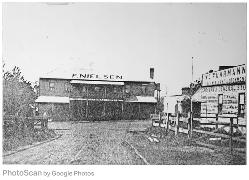
Morwell Bridge was a significant village and should not be forgotten, even though it was swallowed up by that great hole from which we recovered so much brown coal. The bridge was built in 1847 in one of the attempts to develop the ‘Gippsland track’.
The stage coaches stopped at the crossing over the Morwell River, named by C.J. Tyers in 1844 after any one of three or four places in his Devon homeland. This part of the Gippsland Track, (and perhaps it was a part of the Old Sale Road?) developed slowly and it was not until 1858 that P.J.Smith opened the Morwell Bridge Hotel. The opening of hotels at major crossings had obvious advantages, but the coming of the coach services created a symbiotic relationship. A fire at the hotel in 1877 killed sixteen Cobb and Coy horses, four teams, indicating the hotel’s importance as a staging post.
Peter Jeremiah Smith built and opened the Morwell Bridge Hotel in 1858 and was still the licensee in 1873, when he died. He was also the Postmaster. His good lady, Mary Smith, took over the role of postmistress and I assume she acted as the licensee of the hotel as well.
Smith had run a rough little inn at “Hobson’s Bridge”. As Traralgon was called at one time, but Duncan Campbell opened a much better one nearby and Smith became short of business, so he moved.
The next publican I know about was Henry Godridge, who took it over in 1879. Godridge certainly gets the title ‘pioneer’ because he had run a hotel at Russell’s Creek for 14 years beforehand.
I didn’t know much about it but the Morwell Historical Society website tells us “The settlement at Morwell Bridge prospered and in later years was well served by a school, church hall, two general stores (one of which incorporated an unofficial Post Office) and two garages. The town was also able to boast a football ground and a tennis court.
At its peak Morwell Bridge had between fifty to sixty houses and a population of approximately 350 people.”
In 1861 a small survey was carried out on the east bank, with at least four blocks surveyed, but The Morwell Bridge hotel was on the west bank. Thomas Thompson did the survey, and he put the blocks on the south side of the road. He called it only “a small township on the Morwell River”.
The blocks were bought by a W.Smith, who was, some say, a relative of Peter’s, Thomas Sampson and T.F. McCoull. J.Sampson bought the fourth block, but McCoull eventually owned all four blocks and other land nearby.
There is some argument about whether the hotel was on east bank or the west. It seems possible that it might have moved to the east side when the survey was done but that is a very hypothetical suggestion. I believe it more likely that it was on the west bank.
Many of the houses later built were on land leased from J. McKay for two shillings a week. He provided a football ground and a tennis court available free to the community. It sounds like a cliché but it is far more than that to say that the people of Yallourn and Morwell have at times shown an amazing ability to work together and provide for each other, even before the trade unions emphasised that ethos once the mines were operating. One of the references mentions Meredith’s truck collecting people for runs to the ‘flicks’ on a Saturday night, first in Morwell and then in Yallourn as that township was created.
The school was opened in 1881 in a room attached to the Morwell Bridge Hotel (can you imagine that today?) but the arrangement did not last long because all the language used in the bar could be heard very clearly in the classroom. That first head teacher, and the only teacher, was John Bardin, who spent five years at Morwell Bridge State School and perhaps developed his vocabulary more than he wished.
It worked half-time with the Morwell North school (then called the Maryvale North school) for two periods, 1884 to1892 and 1900 to 1904, but was full-time until 1964. That half-time working meant that one teacher travelled between the two schools and the children got a half-time education.
Not that it matters at all but Morwell Bridge State School, No. 2439, was one of the very few, perhaps the only, yellow brick schools in the state, beside the Princes Hwy and surrounded by a little village. One report says there were nearly 200 houses at Morwell Bridge at one stage. It was on the east side of the river, which bought it a few years of survival as the open cut came closer from the west and north. The original school was on the west side of the river, but it died in the 1944 bushfires. So did 51 Victorians. More than 700 were seriously injured and more than 600 homes were lost.
Wiki-something told me “On 14 February (1944) a fire broke out near Hearnes Oak and quickly took hold and destroyed 16 houses and the post office before moving on to Morwell where it burnt down 40 houses and 3 people were killed. The fire also destroyed 40 houses and caused 3 deaths in the Traralgon area.”
Remember that this in 1944, only five years after the terrible fires of 1939. This time, many of the men who could have fought the fires all over Victoria, were busy overseas with an even bigger fight.
The new school was across the river because the State Electricity Commission plan included the site in the growing open cut. From about 1944 the SEC started buying up the houses on the west bank. Eventually a length of the Princes Highway was relocated and Morwell Bridge was no longer on the main road. The end was nigh.
There was no mention of Morwell Bridge in any of my municipal directories. It would have come under the Traralgon Shire until the Morwell Shire was created in 1892 from parts of the Narracan and Traralgon Shires. The Traralgon Shire had been created by severance from the Rosedale Shire.


